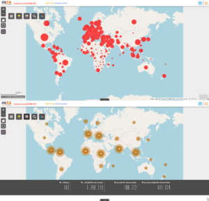

GIS i COVID-19
Za efikasno upravljanje bilo kojom društveno-ekonomskom situacijom ili fizičko-geografskim procesom, ključno je pravovremeno raspolagati informacijama na osnovu kojih se može adekvatno reagovati u realnom vremenu, u skladu sa potrebama. Ovo pravilo nikada nije bilo važnije nego tokom pandemije koronavirusa, kada brzina širenja bolesti i stepen ugroženosti stanovništva zavise od pravovremenog prikupljanja i razmjene informacija.
S obzirom na zaraznu bolest s kojom se čovječanstvo suočilo, a koja se lako prenosi s čovjeka na čovjeka i može imati ozbiljne posljedice, upravljanje krizom – od prikupljanja i razmjene informacija do provođenja operativnih zadataka na terenu – mora biti sistemsko i kontrolisano kroz brz sistem razmjene informacija, uz mogućnost filtriranja podataka prema različitim kategorijama korisnika.
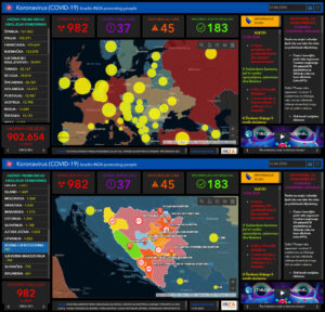
Inženjeri INZA Group razvili su softver za upravljanje rizicima u borbi protiv koronavirusa. Softver se zasniva na digitalizaciji procesa razmjene informacija, analize i procjene, što omogućava brzo i efikasno djelovanje u vanrednim situacijama.
Digitalizacija sistema upravljanja informacijama o pandemiji koronavirusa bazira se na softverskim rješenjima koja omogućavaju interaktivnu razmjenu informacija putem aplikacija, uz pohranu podataka na serveru gdje se oni analiziraju i obrađuju, te prikazuju u realnom vremenu kroz statističke prikaze i interaktivne mape.